
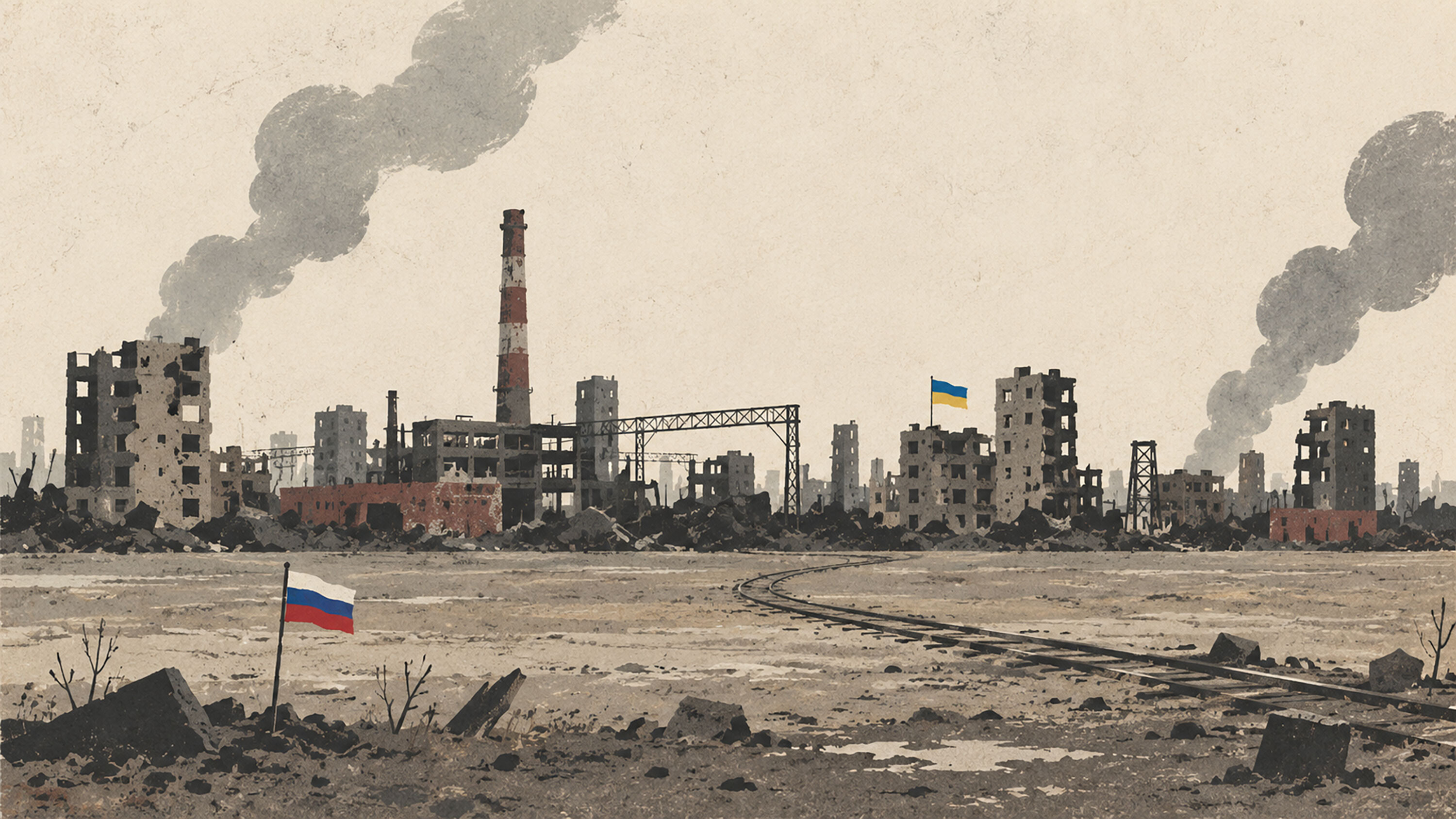
On the map, they may appear as a few remaining points. On the ground, these are interconnected cities, railways, rivers, and fortresses that could swallow years of war.
On a military map, the remaining Ukrainian-held part of Donbas looks like the final bite: a narrow, irregularly shaped stretch of territory that some future agreement might simply switch from one color to another. A source close to the Kremlin claims—at least according to several media reports—that Putin is unwilling to accept the current line of separation until the Russian army controls the rest of Donetsk Oblast and that, based on reports from his commanders, he believes this can be achieved by the end of 2026.
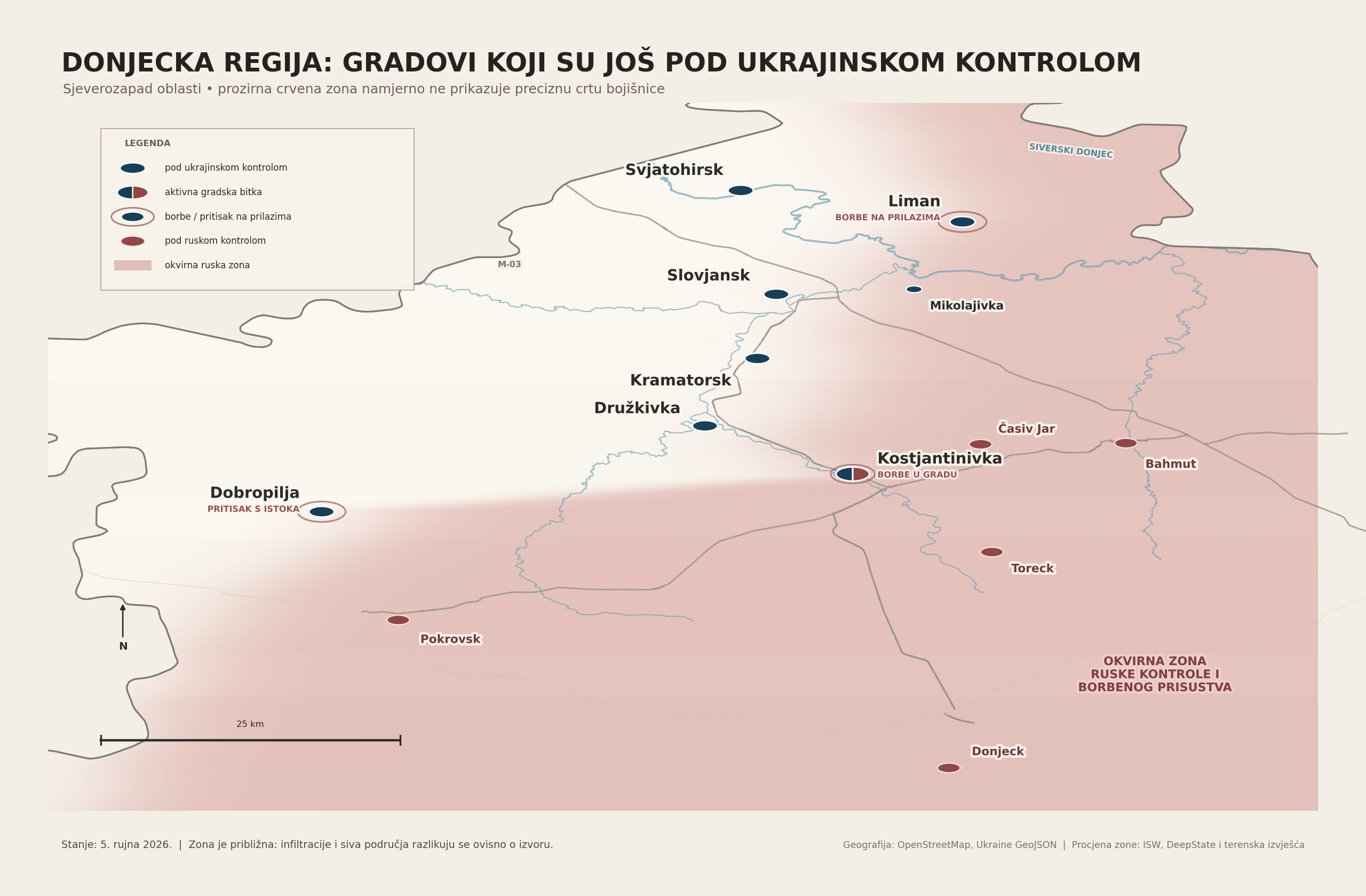
Zoom in on the map, however, and that optimistic deadline begins to look very different. Russia is not facing an empty expanse of steppe, but probably the most difficult territory still under Ukrainian control anywhere in Donbas—a chain of cities, industrial zones, rivers, forests, high ground, mining settlements and prepared defensive positions. The simple political formula of “capturing all of Donbas” may conceal several more battles resembling Bakhmut, except joined together into a single belt roughly fifty kilometers long.
In the current military and diplomatic context, Donbas generally means Donetsk and Luhansk oblasts. Russia controls virtually all of Luhansk Oblast and roughly four-fifths of Donetsk. Ukraine still holds around 5,000 square kilometers of Donetsk Oblast, or approximately 19 percent of its territory. The figure itself does not sound particularly large. The problem for Russia is that this final fifth contains the greatest remaining concentration of Ukrainian cities and defensive infrastructure in the east of the country.
The core of this territory consists of Kostiantynivka, Druzhkivka, Kramatorsk and Sloviansk, a chain of cities strung along the H-20 highway. Before the Russian invasion, more than 380,000 people lived across this wider urban belt. Ukraine has been fortifying it since 2014, when it re-established control over these cities. One settlement runs into the next, industrial plants become natural fortresses, while river valleys, canals, embankments, railway lines and elevated ground funnel military movement into prepared corridors.
Distance from the front is no longer a straightforward geographical measure. Small Russian groups can slip several kilometers through Ukrainian positions, hide in a house or wooded area and raise a flag even though no supply route or stable territorial control exists behind them. A distinction must therefore be made between the furthest forward units, the gray zone and the consolidated line from which the Russian army can actually launch its next attack. On some axes, those three lines may be five, ten or even more kilometers apart.
Kostiantynivka: The battle has already begun
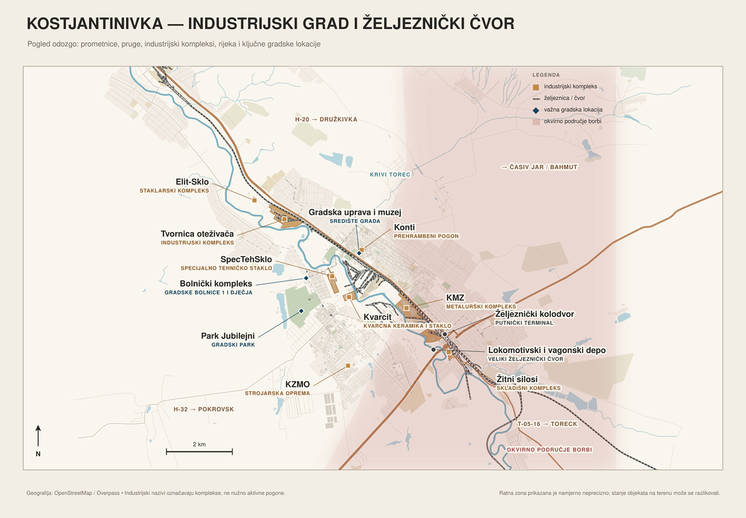
There is little point asking how far the Russian army is from Kostiantynivka. It is already inside the city. By early September, Russian forces had entered large parts of its southern and eastern districts, while smaller groups had penetrated deeper toward the center. Estimates suggesting that a Russian presence has been recorded across more than 70 percent of the city do not mean Moscow firmly controls that much territory. The figure includes unstable areas, ruins traversed by both sides and isolated groups that may be cut off or destroyed.
Kostiantynivka had a prewar population of around 67,000. The city lies on the Kryvyi Torets River, whose valley divides the urban area and limits the number of suitable crossing points. Railway tracks, embankments, working-class neighborhoods and large industrial plants break the battlefield into separate sections. An attacker may capture one district only to encounter another branch of the river, a factory, a railway line or a row of buildings converted into individual strongpoints.
Russia’s advantage is that the Ukrainian defense here has already been seriously weakened. The city lacks the defensive depth of Kramatorsk and Sloviansk, while its northern connections are exposed to drones, artillery and airstrikes. Russia is pressing it from several directions: from the south and southeast, along the Toretsk and Chasiv Yar axes, and toward the northwestern exits leading to Oleksiievo-Druzhkivka. The objective is not necessarily to seize every building, but to make the remaining Ukrainian positions untenable and force their defenders to withdraw.
The fall of Kostiantynivka therefore appears to be the most likely next major Russian success in Donbas. Yet even after completing its capture, the Russian army would not emerge onto an open road to Kramatorsk. Satellite settlements, new defensive positions and Druzhkivka—the next urban strongpoint—would still stand in its way.
Estimated difficulty of capture: relatively high. The battle is at an advanced stage, but converting a broad zone of Russian presence into stable control may still require considerable time, manpower and ammunition.
Druzhkivka: The city holding the defensive belt together
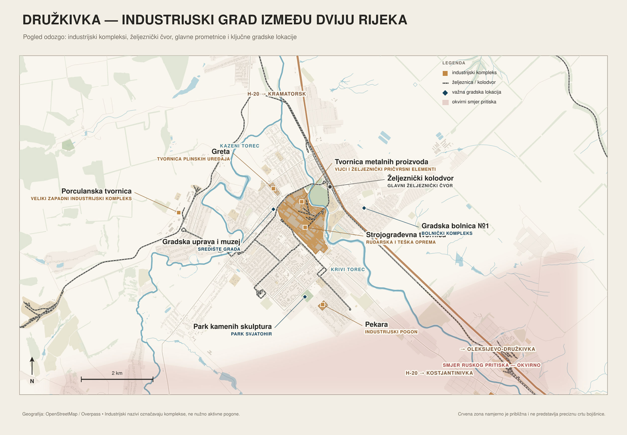
Druzhkivka is smaller than Kramatorsk and Sloviansk, but its location gives it an importance far greater than its population would suggest. The city, once home to approximately 54,000 people, lies between Kostiantynivka and Kramatorsk, where the valleys of the Kryvyi Torets and Kazennyi Torets meet. Road and rail links run through an industrial urban area that literally connects the southern and northern sections of Ukraine’s defensive belt.
The bulk of confirmed Russian positions lies approximately ten to fifteen kilometers from the city, although infiltration groups have been recorded near Raiske, only a few kilometers from its southern outskirts. Russia’s military leadership has claimed that its forces came within just a kilometer and a half of Druzhkivka, but open-source evidence does not confirm the existence of a stable Russian line there. As usual, interpretations vary depending on the source.
The first obstacle on the southern approach is Oleksiievo-Druzhkivka. Capturing it would allow Russian forces to move closer to the city along the main road, while an advance from the west could threaten its connections with Dobropillia. Druzhkivka could then go from a rear-area city to a semi-encircled battlefield almost overnight.
Factories, railway facilities, river valleys and densely built neighborhoods favor the Ukrainian defenders. The weakness is the lack of operational depth: severing a handful of key roads could isolate the city from Kramatorsk, leaving Ukraine to choose between a prolonged defense under encirclement and withdrawal. Russia may therefore try to break Druzhkivka through isolation rather than by mounting frontal assaults on every district.
Estimated difficulty of capture: very high. As long as its northern and western connections remain open, the city is a formidable obstacle. Its position would deteriorate rapidly if Kostiantynivka fell while Russian forces simultaneously advanced toward the Dobropillia–Kramatorsk road.
Dobropillia: Going around the wall instead of through it
Dobropillia is not part of the four-city core along the H-20. It lies farther west, in a more open mining landscape, and had a prewar population of around 28,000. Its value lies less in the size of the city itself than in the roads running through it toward Kramatorsk and Sloviansk.
The most advanced Russian groups have appeared on the eastern and southeastern approaches, while the consolidated line generally remains between five and ten kilometers away. Some reports of Russian forces entering “Dobropillia” may cause confusion because a smaller settlement with the same name lies south of the city. There is so far no confirmation that Russia controls any substantial part of the city itself, but the battle for its outskirts and surrounding villages has clearly begun.
Advancing on this axis would offer Moscow an opportunity to bypass the strongest section of Ukraine’s defenses. Instead of attacking through Druzhkivka toward Kramatorsk, Russian forces could try to cut the T-05-14 road, reach the western flank of the entire conurbation and threaten its supply routes from Dnipropetrovsk Oblast. Dobropillia is thus a kind of door handle on a door that cannot easily be broken down.
The open terrain around the city makes it easier to identify weak points and infiltrate small infantry groups. At the same time, the area is closely watched by drones, meaning any Russian advance must be supplied through a long, exposed corridor. That problem was already evident in 2025, when Russian units suddenly pushed deep into this sector but failed to turn their narrow salient into a sustainable operational breakthrough.
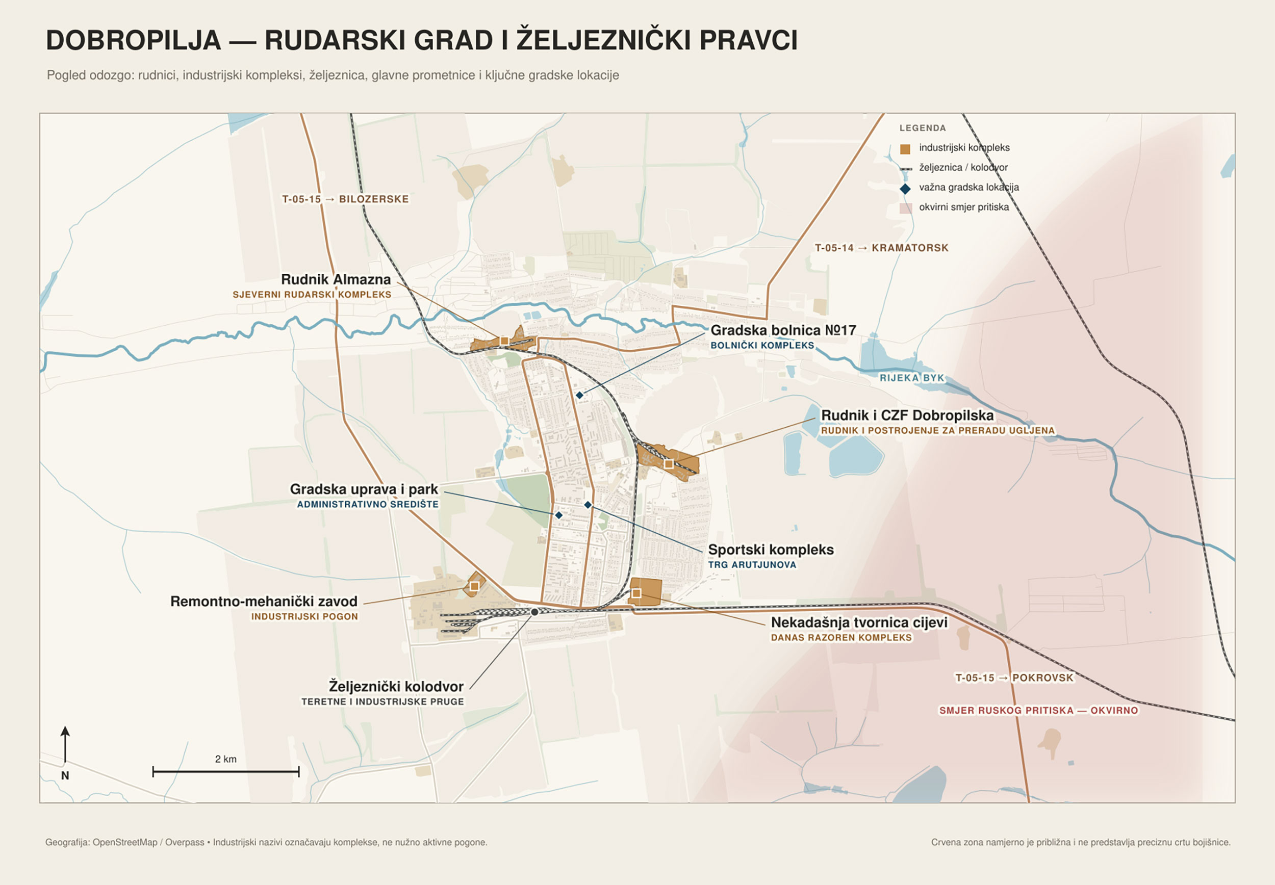
Estimated difficulty of capture: high. Dobropillia is a smaller and more isolated target than the cities of the main defensive belt, but sustaining a Russian advance and severing Ukrainian communications would be more difficult than simply entering the city.
Kramatorsk: The administrative and logistical heart of Ukrainian Donbas
Kramatorsk is the largest city Russia would still have to capture if it intends to control all of Donbas. Before the invasion, it had a population of approximately 147,000. After Ukraine lost Donetsk in 2014, Kramatorsk became the provisional administrative capital of the Ukrainian-controlled part of Donetsk Oblast. Its railway connections, workshops, warehouses, enormous heavy-engineering plants and road links shaped the city for decades—and now define its military value.
According to more cautious estimates, consolidated Russian positions lie roughly ten to fifteen kilometers from Kramatorsk’s eastern outskirts. Small infantry groups have penetrated considerably farther and come within approximately seven kilometers of the military airfield on the city’s eastern side. Claims by Russia’s military leadership that fighting is taking place only a few kilometers from Kramatorsk do not yet correspond to the confirmed line of control.
Before launching a serious urban operation, the attacker would have to seize a series of positions east of the city, including the area around the Siverskyi Donets–Donbas Canal, while threatening Kramatorsk’s links with Sloviansk, Druzhkivka and the west. As long as the city can receive troops, ammunition and equipment from several directions, a frontal assault would be extraordinarily costly.
Its industrial geography compounds the problem. Vast factory halls, thick walls, underground spaces, railway embankments and separate residential districts would allow the defense to be organized in several layers. The city need not be defended as a single unbroken line. It could become a network of fortified strongpoints that the attacker would have to bypass, isolate or destroy one by one.
Kramatorsk also forms part of a wider urban system with Sloviansk. Russia would not be attacking an isolated fortress, but two large cities sharing logistics, roads and defensive depth. That connection could become a weakness if their common supply routes were severed, but as long as those routes remain operational, each city protects the approaches to the other.
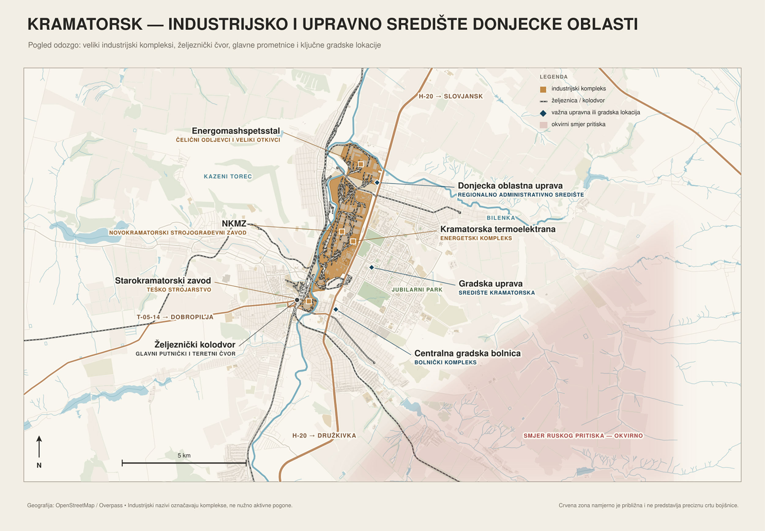
Estimated difficulty of capture: exceptionally high. Kramatorsk would probably be the costliest single urban operation still remaining in Donbas. A faster collapse would be possible only after serious encirclement and a breakdown of logistics—not through a simple continuation of the current frontal advance.
Sloviansk: The city where this war first took shape
Sloviansk carries a weight that cannot be measured by looking at a map alone. It was here that Igor Girkin’s forces—led by the man also known as “Strelkov”—seized control in April 2014, turning a local uprising into an organized war. The Ukrainian army retook the city after almost three months of fighting. Twelve years later—yes, it has already been that long—Russian forces are approaching it once again, this time facing defenses that have had more than a decade to prepare.
The city had a pre-invasion population of around 105,000. In early September, the confirmed Russian line stood approximately seven to ten kilometers from its eastern approaches, although some estimates place the consolidated positions somewhat farther away. Russian forces have appeared near Mykolaivka, closer to Sloviansk’s outskirts, but Ukrainian troops have pushed them back. Such incursions do not yet provide a basis for an attack on the city.
Sloviansk’s geography is particularly hostile to an attacker. To the north and northeast lie the Siverskyi Donets River, forests, lakes, marshland and a limited number of crossings. The eastern approach runs through Mykolaivka and Raihorodok, while any advance from the southeast would have to cross a series of elevated and prepared defensive positions. Russia’s attempt to approach from the northeast also depends on the battle for Lyman.
Sloviansk is also an important road and railway junction. The M-03 highway connects it with Izium and Kharkiv Oblast, while the routes toward Kramatorsk keep both cities within a common defensive system. Before launching a general assault, Russia would therefore probably try to sever the connections with Kharkiv and the west, turning the entire conurbation into an enormous and steadily tightening drone zone.
The city’s symbolic value could prompt Moscow to commit exceptional resources to capturing it. Yet symbolism does not change the terrain. Russia would have to connect at least three axes of advance, protect its own logistics and deploy enough infantry to clear a city whose wider urban area is considerably larger than Bakhmut.
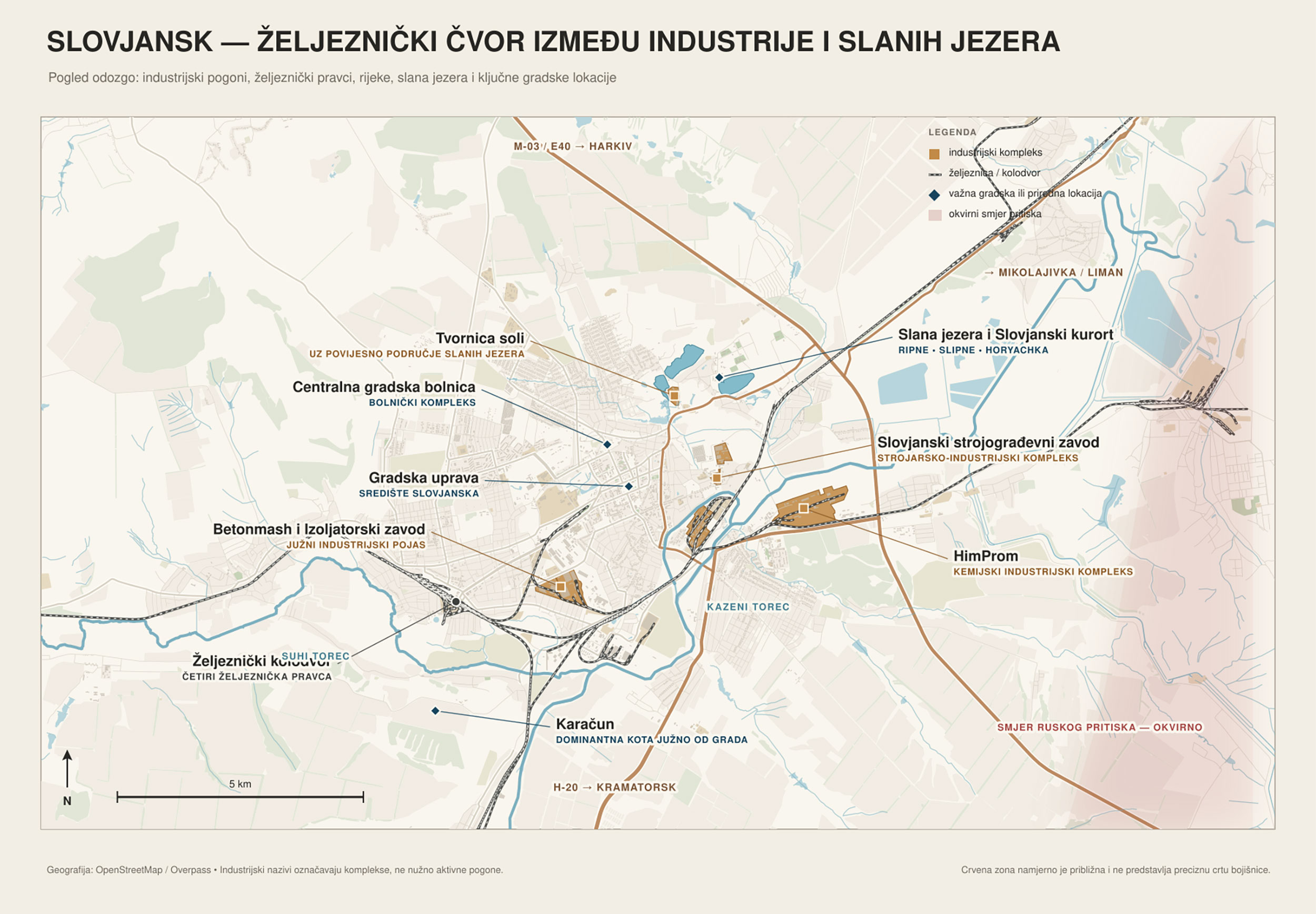
Estimated difficulty of capture: exceptionally high. Together, Sloviansk and Kramatorsk form the final and most difficult core of the campaign. Treating them as separate objectives creates a misleading picture, because the battle for one would almost inevitably spill into the battle for the other.
Lyman and Sviatohirsk: The northeastern gateway through forests and rivers
Lyman had a prewar population of only around 20,000, but its location is worth far more than its size would suggest. The city sits on an important railway route and guards the northeastern approach to Sloviansk. Russia captured it in May 2022, before the Ukrainian army retook it during the autumn counteroffensive that same year. A new battle for its approaches has now been underway for months.
The most advanced Russian groups periodically reach the city’s eastern and southern outskirts, while more stable positions remain several kilometers away. During August, Ukrainian forces conducted local counterattacks north and south of Lyman, cleared several infiltration zones and pushed the threat away from certain supply routes. It is therefore impossible to draw a single clean line there: forests and ruined settlements create a broad area in which positions frequently change hands.
The forests around Lyman conceal small assault and reconnaissance groups, but also make it difficult to deploy larger armored formations. The Siverskyi Donets, its floodplains and the limited number of crossings further restrict movement. The city has been heavily damaged and its railway infrastructure no longer possesses its former value, but Russian control would open a more favorable route toward Sloviansk and free up forces to attack the northern section of the main defensive belt.
Sviatohirsk, a smaller city northwest of Lyman, is important as part of the same forested and riverine landscape. In early September, Putin claimed that Russian forces had captured it, but neither the available evidence nor some Russian military sources confirmed that assertion. Footage presented as evidence proved to be old and subsequently altered, while the closest confirmed Russian positions were approximately ten kilometers away, beyond difficult terrain. The episode neatly illustrates how much the map shown to the political leadership can differ from the actual front line.
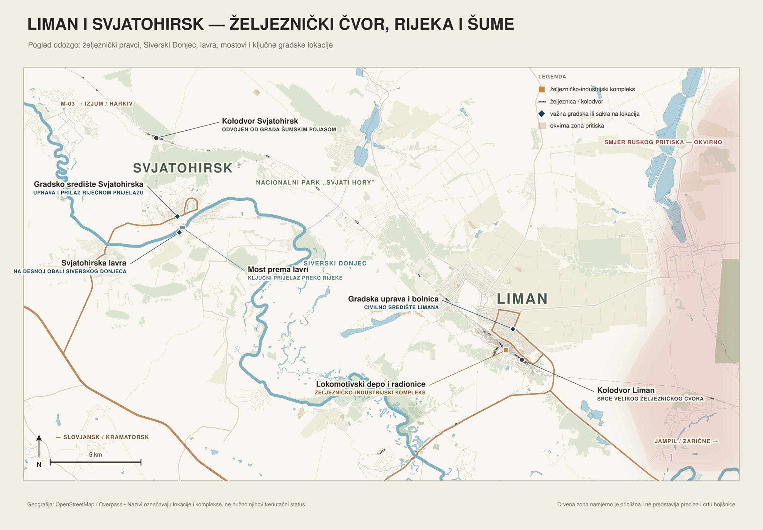
Estimated difficulty of capturing Lyman: very high. The city is far smaller than Kramatorsk or Sloviansk, but the forests, rivers, Ukrainian counterattacks and years of defensive preparation neutralize much of Russia’s advantage in manpower and firepower.
The final fifth could be harder than the first four
Even the fall of every city listed here would not automatically place every corner of Donetsk Oblast under Russian control. Smaller settlements and a western defensive line stretching through Bilozerske, Novodonetske and Oleksandrivka toward the administrative border would remain. Yet the terrain west of the main urban belt is more sparsely populated, contains fewer natural obstacles and gradually gives way to flatter steppe. If Kramatorsk and Sloviansk fell, the remainder of the campaign could proceed more rapidly.
This is why simply dividing the remaining territory by the current rate of Russian advance cannot produce a reliable deadline. During August, according to confirmed geolocation data, the Russian army firmly captured around 90 square kilometers across the entire Ukrainian front, while Putin spoke of 270 square kilometers in Donetsk Oblast alone. If the present pace continues, capturing approximately 5,000 square kilometers cannot be completed by the end of the year. Of course, the collapse of a major defensive hub could trigger a retreat across a much wider area, just as a Ukrainian counterattack could once again push the front line farther away.
Russia has larger manpower reserves, an overwhelming advantage in glide bombs and the ability to maintain pressure for months despite heavy losses. Ukraine is short of infantry, depends on external assistance and must defend an extremely long front. None of these cities is therefore impossible to capture. But there is a vast difference between the possibility of capturing them and doing so within a matter of months.
Finally, controlling all of Donbas must be distinguished from fulfilling Russia’s entire war program. Putin has publicly stated that control of Donbas and reaching an agreement are not mutually contradictory, while the Kremlin has described the withdrawal of Ukrainian troops from the region as a condition for ending the war’s “hot phase.” Yet the claim that Putin will not accept the present line before the rest of Donetsk Oblast has been taken—and expects this to happen by the end of 2026—still comes from anonymous sources rather than any officially announced Russian deadline.
Even the last city on the border of Donetsk Oblast therefore need not become the last city of this war. Russia’s official demands still encompass Zaporizhzhia and Kherson oblasts, Ukraine’s neutral status and what Moscow frequently calls the “elimination of the root causes of the conflict.” Capturing all of Donbas might give Putin a sufficiently large victory to begin final negotiations, but there is no guarantee that the Russian army would stop there.
The Russian army may indeed now be seven kilometers from the outskirts of Kramatorsk or ten kilometers from Sloviansk. That does not mean it is equally close to the end of the war. Between Russia’s current positions and control of the entire Donbas stands a chain of cities in which the final 19 percent of the territory may prove harder to capture than the previous 81 percent. Something truly dramatic would have to happen for Russian forces to take all of it by the end of this year. Yet few can say with any certainty where the war’s real “end” lies. A new American diplomatic effort is now underway, but when the entire military map is taken into account, this war still appears to be a long way from its final silence.
Sources
- Understandingwar.org The Importance of Ukraine's Fortress Belt: Geospatial Intelligence Terrain Analysis https://understandingwar.org/research/russia-ukraine/the-importance-of-ukraines-fortress-belt-geospatial-intelligence-terrain-analysis/
- Reuters Russia pounds on the gates of Ukraine's 'fortress belt' https://www.reuters.com/world/europe/russia-pounds-gates-ukraines-fortress-belt-2026-06-29/
- Rferl.org Rescuers Dodge Air Strikes To Evacuate Donetsk Region City https://www.rferl.org/a/mass-evacuations-from-ukraine-druzhkivka-under-russian-airstrikes/33803288.html
- Pravda.com.ua Battlefield sees over 250 clashes: Russians attempt to break defence on Lyman front – Ukraine's General Staff https://www.pravda.com.ua/eng/news/2026/08/10/8048029/
- The Guardian Kill zones and drone nets: a journey through Ukraine’s fortress belt https://www.theguardian.com/world/ng-interactive/2026/jul/03/kill-zones-drone-nets-journey-ukraine-fortress-belt
- Deepstatemap.live DeepStateMAP | Map of the war in Ukraine https://deepstatemap.live/en
- Associated Press Ukraine faces a new test as Russia steps up its drive to seize Donetsk’s fortress belt https://apnews.com/article/6155c773ce5c43ed3a6b6905194d76da
- Kyivindependent.com Analysis: Russia breaks into Kostiantynivka, opening battle for Donbas fortress belt https://kyivindependent.com/analysis-russia-breaks-into-kostiantynivka-opening-battle-for-donbas-fortress-belt/
- Osw.waw.pl The Russians are advancing towards Sloviansk and Kramatorsk. Day 1462 of the war https://www.osw.waw.pl/en/publikacje/analyses/2026-02-24/russians-are-advancing-towards-sloviansk-and-kramatorsk-day-1462-war
- Encyclopediaofukraine.com Donetsk oblast https://www.encyclopediaofukraine.com/display.asp?linkpath=pages%5CD%5CO%5CDonetskoblast.htm
Comments